The Nigerian Institution of Surveyors (NIS) has called the annual updating of map and testing to curb building collapse and flooding in Nigeria.
NIS Lagos branch made the call during its 2023 Mandatory Continuing Professional Development (MCPD) workshop with the theme: ‘Comparative Analysis of Building Information Model For Structural Health Monitoring,’ in Lagos.
The association also advised Nigerians to engage professional surveyors for documentations towards getting genuine Certificate of Occupancy (C of O) to prevent loss of investments through collapse, flooding or forfeiture.
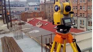
Chairman, NIS, Lagos branch, Mr Olukolade Kasim, called for regular monitoring of infrastructure towards determining their structural health and stability, using modern tools like scanners to prevent faults that might develop underneath the earth crust.
He said regular monitoring of bridges and high buildings was important, urging the Lagos State government to create a ministry attached to the Surveyor General’s office for the purpose of monitoring and testing buildings.
Kashim explained that highrise buildings constructed with best globally accepted procedures and standards could become sick as a result of movement underneath the earth, hence the need for periodic tests.
He cited the example of a bridge at Bonny Camp area in Lagos which was noticed to have one of its pillars shifting before the government fixed the problem to avert collapse.
“We are recommending that bridges and tall ranking buildings should be monitored periodically,” he said.
Kasim said the workshop was organised to train and retrain members for best standards to curb the menace of building collapse and flooding.
According to him, the NIS usually collaborated with all the other six built environment experts including architects, engineers, builders, town planners, amongst others towards construction of solid structures.
Chairman of the 2023 Workshop Planning Committee, Adedeji Sebiotimo, called for annual updating of the Lagos map for proper planning to capture new settlements.
Sebiotimo, a fellow of NIS and vice-chairman of Lagos State branch, said updated mapping would reveal accurate topography of land, either high or low, as a determinant of what and where to build without the risks of flooding or collapse.
From the mapping results, he said one would be able to know areas that had infrastructure or those lacking infrastructure in terms of roads or developments.
“A lot of things can be seen from the map,” according to Sebiotimo.
He said in 2022, 320 surveyors registered for the workshop, but that 495 registered for the 2023 programme, aimed at exposing surveyors to current trends to reshape their knowledge and skills.
The guest speaker, Dr Joseph Odumosu, explained common errors made by civil engineers and other built environment professionals in trying to hijack the roles of surveyors.
He advised surveyors not to certify projects that they did not supervise to avoid being liable for unethical practices and failure of the structures.
Odumosu, a lecturer at Federal University, Oye-Ekiti, said scanners should be used for proper imagery of highrise as well as to determine the health of the buildings using new technologies.
Another guest speaker, Mr Awofeko Abiodun, said that publicity was needed for the public to harness opportunities of GIS departments in all the states to strengthen Land Information System and Land Administration Systems.